![Pisgah Ranger District Map [Pisgah National Forest] (National Geographic Trails Illustrated Map, 780)](https://travelswithme.org/wp-content/uploads/2025/11/pisgah-ranger-d_0.jpg)
![Pisgah Ranger District Map [Pisgah National Forest] (National Geographic Trails Illustrated Map, 780) - Image 2](https://travelswithme.org/wp-content/uploads/2025/11/pisgah-ranger-d_1.jpg)
![Pisgah Ranger District Map [Pisgah National Forest] (National Geographic Trails Illustrated Map, 780) - Image 3](https://travelswithme.org/wp-content/uploads/2025/11/pisgah-ranger-d_2.jpg)
![Pisgah Ranger District Map [Pisgah National Forest] (National Geographic Trails Illustrated Map, 780) - Image 4](https://travelswithme.org/wp-content/uploads/2025/11/pisgah-ranger-d_3.jpg)
![Pisgah Ranger District Map [Pisgah National Forest] (National Geographic Trails Illustrated Map, 780) - Image 5](https://travelswithme.org/wp-content/uploads/2025/11/pisgah-ranger-d_4.jpg)
![Pisgah Ranger District Map [Pisgah National Forest] (National Geographic Trails Illustrated Map, 780) - Image 6](https://travelswithme.org/wp-content/uploads/2025/11/pisgah-ranger-d_5.jpg)
![Pisgah Ranger District Map [Pisgah National Forest] (National Geographic Trails Illustrated Map, 780) - Image 7](https://travelswithme.org/wp-content/uploads/2025/11/pisgah-ranger-d_6.jpg)
![Pisgah Ranger District Map [Pisgah National Forest] (National Geographic Trails Illustrated Map, 780) - Image 8](https://travelswithme.org/wp-content/uploads/2025/11/pisgah-ranger-d_7.jpg)
Description
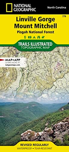
Explore the breathtaking Pisgah Ranger District with the National Geographic Trails Illustrated Map (780). This expertly crafted map is your ultimate guide to navigating the stunning landscapes of Pisgah National Forest. Featuring detailed topographic information, this map highlights hiking trails, campgrounds, and points of interest, making it an essential tool for outdoor enthusiasts.
With its waterproof and tear-resistant material, the Pisgah Ranger District Map is designed to withstand the rigors of the wilderness, ensuring durability on all your adventures. The map includes essential features such as elevation contours, trail mileage, and GPS coordinates, allowing you to plan your journey with confidence.
Whether you’re an experienced hiker or a casual nature lover, this map provides the information you need to discover the diverse ecosystems and scenic beauty of the Pisgah Ranger District. Don’t miss out on the opportunity to enhance your outdoor experience—grab your National Geographic Trails Illustrated Map today and embark on your next adventure in Pisgah National Forest!


![Linville Gorge, Mount Mitchell Map [Pisgah National Forest] (National Geographic Trails Illustrated Map, 779)](https://travelswithme.org/wp-content/uploads/2025/11/linville-gorge-_0-224x224.jpg)